Yeah! It would have added some spice to the Surprise Day celebrations...
You seem to be VERY Happy Today
What have you heard

Last edited:
Yeah! It would have added some spice to the Surprise Day celebrations...

Why so?Unless IAF starts Bombing POK , there is no question of any forward movement
On the ground
Why so?
As on date, IA has far superior precision strike capability in hilly areas compared to IAF.lack of precision strike
As on date, IA has far superior precision strike capability in hilly areas compared to IAF.
some of the missile with IA can do it better than IAF as IAF will need to go behind and turn around to fire at those positions.Indirect fire behind the hills in bunker?
some of the missile with IA can do it better than IAF as IAF will need to go behind and turn around to fire at those positions.
for your information, any action across LOC will be a joint ops by three services. Please calm down and understand my posts. It could be that I am posting things to confuse or build a narrative. Kahin pay nigahain, kahin pay nishaana.IAF will have to move in if we are really serious about occupying territory
Once Rear Areas become in operational
Then the holding of forward areas becomes untenable
If they use helicopters , then they can
Also be targeted by IAF
Defenders have a huge advantages in
Mountainous terrain
Therefore Air power is necessary for the aggressor
In Kargil IAF played the most important role , though we were evicting them from
Our territory
This battle will be much more difficult than Kargil
I really wonder what kind of Force planning we have done for Taking POK
for your information, any action across LOC will be a joint ops by three services. Please calm down and understand my posts. It could be that I am posting things to confuse or build a narrative. Kahin pay nigahain, kahin pay nishaana.
Leave it to those who are in saddle right now. But I do know what is cooking and its ingradients.But How do we "SELL " the Narrative of Crossing the IB or using the NAVY
To the International community
Maximum we can go inside the 198 KM
Jammu Border , which they call as WORKING Boundary

Leave it to those who are in saddle right now. But I do know what is cooking and its ingradients.
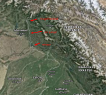
Let me post something very interesting for you.
View attachment 14408
The Dogra Rajputs were not idiots. They took full control of high ground. The pir Panjal range is the limit of their territory. If we make the erstwhile boundary of J&K state before 1947 as our national boundary, we have less distance between Islamabad and Rawalpindi from our territory than what we have between Amritsar and Lahore.
NOCould you please drop some hints
Within our arty range and that will help us block the route to GB. Pakistan did not develop alternate routes for GB. Once we take over certain part of POJ, we can starve them to death in GB.How much distance is that from the LoC
Let me post something very interesting for you.
View attachment 14408
The Dogra Rajputs were not idiots. They took full control of high ground. The pir Panjal range is the limit of their territory. If we make the erstwhile boundary of J&K state before 1947 as our national boundary, we have less distance between Islamabad and Rawalpindi from our territory than what we have between Amritsar and Lahore.
NO
Within our arty range and that will help us block the route to GB. Pakistan did not develop alternate routes for GB. Once we take over certain part of POJ, we can starve them to death in GB.
But there is a feature Shikar gali just west of Athmuqam, and that looks towards west NH to Islamabad and Skardu and towards East Athmuqam and LC. If I am correct, then Pakistanis might have an Observation post out there as it is the highest feature in the area. From there they can observe for miles. I don' t know if Army can spot. Even if Indian forces enter Athmuqam or surrounding they can shell from above.
